Plotting the Coordinates and Projections of Pensacola, Florida(Hometown of LtCol (Dr) Michael L. Thomas)
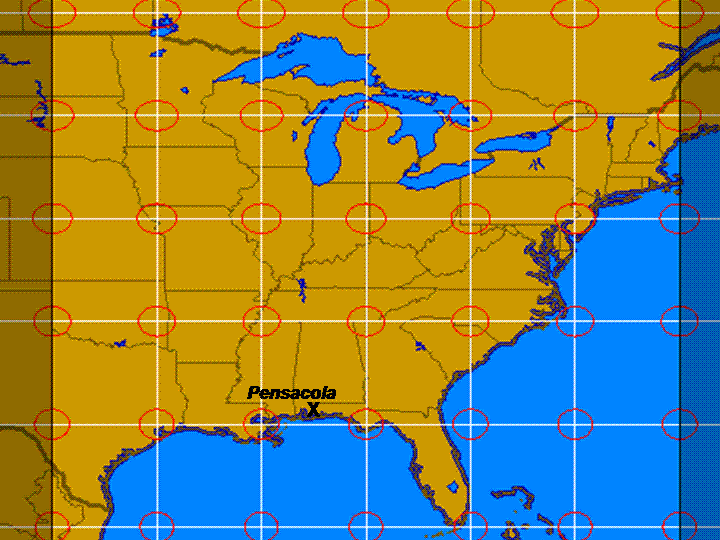
Approximate location of Pensacola, Florida denoted by an "X". | ||||||||||||||||||||||||||||||||||||||||||||||||||||||||||||||||||||||||||||||||||||||||||||||||||||||||||||||||||||||||||||||||||||||||||||||||||||||||||||||||||||||||||||||||||||||||||||||||||||||||||||||||||||||||||||||||||||||||||||||||||||||||||||||||||||||||||||||||||||
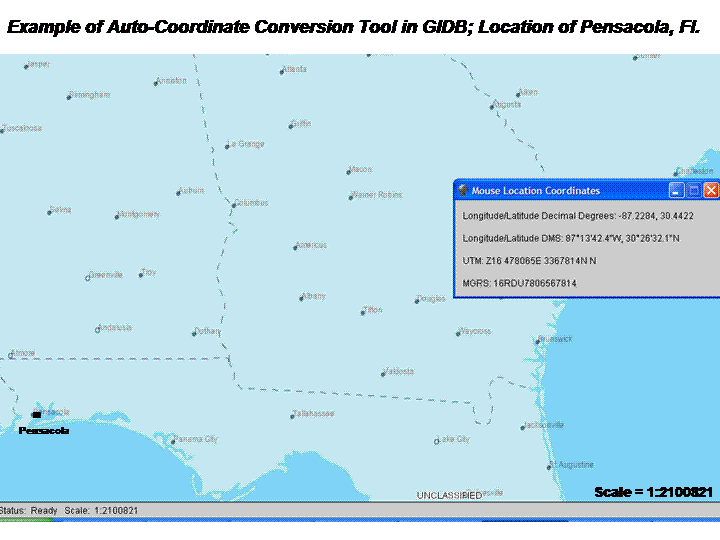
The approximate location of Dr. Thomas’ hometown of Pensacola, Florida is shown in the map above, denoted by a large black “X”. The map was generated on the PSU Interactive Projections website. It is a Plate Carree (Geographic) projection that is one of several favorite styles of projection of Dr. Thomas. Briefly, it can be classified as a cylindrical and equidistant projection. The bounding box of the map are the longitudes of N55 and S20, and the latitudes of W100 and W70. It emphasizes the Eastern seaboard and the northern Gulf Coast of the North American continent, with the island of Cuba as the predominant geographic feature on the south extent of the map.This particular projection is an ancient one and distorts both shape and area. The reference ellipses are only circles at the equator. The areas of the ellipses vary widely and the scale, while true along the equator and meridians, increases with distance from the equator along the parallels, so one scale is not quoted as a feature in this map. It is constant along any parallel, and is the same scale on the opposite side of the globe. This projection was actually typical of maps of the 15th and 16th centuries when the dominating features of many maps created during this period were the shapes of the landmasses which reflects the maturity of navigation technology used since ancient times when this projection was probably invented. Navigation had historically been a coastal endeavor, so this projection was sufficient in areas like the Mediterranean and along the established coastal trade routes (read - within sight of land!). Latitude was easy to reference with relation of the stars and the sun to your present position. Simple shapes of bays, inlets and coastal features was sufficient for ships not venturing far from land. Deep sea voyages of exploration later had to deal with the difficulty in determining the longitude of a ships location - which was was not a trivil task. Longitude required an estimate of the difference in times between where you currently were and a known, fixed point. Much work was done by the Portuguese (Van Helden) and other sailing nations until this problem was finally solved by the Englishman, John Harrison who invented a practical navigational timepiece (Marine Chonometer) in the late 18th century. His goal was to capture the “Longitude Prize” which was established by Parliament in 1714 after the disastrous wreckage of a British Fleet in 1707. The fleet navigators thought they were in mid ocean. They were not - they ran aground in the Isles of Scilly with the loss of over 2000 sailors. Although he had a better solution than the other compettiors, King George III literally had to order Parliament to award him the prize.Using the GIDB mapping software (which includes a automatic coordinate converter) downloadable from http://dmap.nrlssc.navy.mil/dmap/, I was able to find the coordinates of Pensacola by placing the mouse cursor over a location in the city. The output appeared as such:
| ||||||||||||||||||||||||||||||||||||||||||||||||||||||||||||||||||||||||||||||||||||||||||||||||||||||||||||||||||||||||||||||||||||||||||||||||||||||||||||||||||||||||||||||||||||||||||||||||||||||||||||||||||||||||||||||||||||||||||||||||||||||||||||||||||||||||||||||||||||
| Geographic Coordinates
of Pensacola The place name shown on the map above represents the location of my home town. The geographic coordinates of Pensacola are roughly: | ||||||||||||||||||||||||||||||||||||||||||||||||||||||||||||||||||||||||||||||||||||||||||||||||||||||||||||||||||||||||||||||||||||||||||||||||||||||||||||||||||||||||||||||||||||||||||||||||||||||||||||||||||||||||||||||||||||||||||||||||||||||||||||||||||||||||||||||||||||
| Latitude: 30° 26' 32"N, Longitude:
87° 13' 42"W
(although keep in mind this is only 1 point. More detailed locations from USGS are tabularized below.) | ||||||||||||||||||||||||||||||||||||||||||||||||||||||||||||||||||||||||||||||||||||||||||||||||||||||||||||||||||||||||||||||||||||||||||||||||||||||||||||||||||||||||||||||||||||||||||||||||||||||||||||||||||||||||||||||||||||||||||||||||||||||||||||||||||||||||||||||||||||
|
The geographic coordinate system is partially based on a sexigesimal (base 60) system first used by the Babylonians and partially based on a decimal system (Troutman). Due to their interest in astrology, the Babylonians were interested in extreme accuracy of measure - the sexigesimal system provided that accuracy for their astrological observations. The full coordinate (Degree Minute Second (DMS)) is divided into 0-90 degrees north and south starting at "0" degrees at the equator and ending at "90" degrees at both the north and south poles. This is the decimal portion of the coordinate. The second and third components are divided into 60 increments each - 60 minutes per degree and 60 seconds per minute. The reference line for longitude is the prime meridian and is decremented in units of DMS east and west from 0 to 180 similar to latitude. Note- going east and west lands you on a common 180 latitude - 180E is the same line as 180W. A system like this is called "unprojected." If the earth were a perfect sphere this would be a very accurate system for perfectly locating a position. Since of course the earth is not perfectly spherical, inaccuracies emerge for various uses (such as representing spherical coordinates on a flat piece of paper) - hence the need for various types of "projections". Projected simply means it is a map projection drawing the lines representing the meridians longitude and parallels of latitude from an unprojected geographic system onto a flat surface. Because the earth is not a perfect spherical body (it bulges some at the equator among other issues) different ellipsoids are used for the projection of data. The North American Datum of 1927 (NAD27) is based on an ellipsoid established by Clarke in 1866, whose reference base station is located on the Meade's Ranch in Kansas. The use of this datum is being replaced by the more modern North American Datum of 1983 (NAD83). With the advent of modern electronics and satellite technology, the size, shape and center of gravity pf the earth was measured and calculated to two meters (DiBiase, 2007). While there are literally tens of thousands of control monuments in place based on the NAD27 datum (hence the reason it is still in some use), the amount of differences is well known and documented. Converting from 1 datum to another is not difficult, although it is not uniform geographically by any means. The differences between the two datums varies from 200-350 feet in the Western US, to tens of feet in the Central Plains and Eastern seaboard of the US. Other locations are available online from the GNIS locator of the USGS. Query Results from GNIS Locations in Pensacola (Courtesy USGS Search Engine)
| ||||||||||||||||||||||||||||||||||||||||||||||||||||||||||||||||||||||||||||||||||||||||||||||||||||||||||||||||||||||||||||||||||||||||||||||||||||||||||||||||||||||||||||||||||||||||||||||||||||||||||||||||||||||||||||||||||||||||||||||||||||||||||||||||||||||||||||||||||||
| Universal Transversal
Mercator (UTM) Coordinate System | ||||||||||||||||||||||||||||||||||||||||||||||||||||||||||||||||||||||||||||||||||||||||||||||||||||||||||||||||||||||||||||||||||||||||||||||||||||||||||||||||||||||||||||||||||||||||||||||||||||||||||||||||||||||||||||||||||||||||||||||||||||||||||||||||||||||||||||||||||||
| Easting: 478065E, Northing:
3367814N, Zone: 16
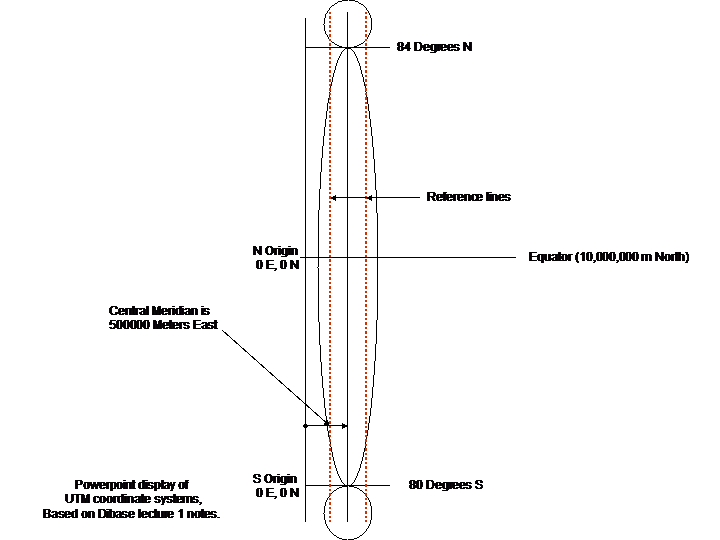
The UTM coordinate system divides the earth into grids and is another way of locating positions on earth. It is based on a division at the equator of the earth into 60 zones with a width of 6 degrees each (6x60 = 360). Each zone is based on it's own reference projection independent of the others. While the divisions around the equator are complete, the zones only go north and south to 84 and 80 degrees respectively. (The polar regions use a different projection). Since this area contains most of the earth's surface, for most applications it is very useful. Again, each zone has it's own unique Tranverse Mercator projection and a "projected" system of coordinates. This projection allows a great deal of the surface of the earth to be mapped with a minimum of distortion. There is a central meridian in each zone and 2 parallel reference lines approximately 180 kilometers east and west of the central meridian. Although some distortion is present, the amount of error within the zone is less than 1 part in 1000. The "Easting" in this system is given relative to a reference central meridian (see diagram below) in each zone being represented as 500,000 meters east of the origin. The "Northing" is represented differently in a Zone north of the equator versus south of the equator - see "origins" in the diagram below. From the origin the coordinates in the North Zone range from 0-10,000,000 meters increasing north from the equator and the coordinates of the South Zone range from 0 to 10,000,000 meters where 10,000,000 is the same as 0 (the equator) in the North Zone. In summary, the Northing "0" starts at 80 degrees south and increase to the equator in the southern zones while it starts at the equator and increase to 84 degrees north in the northern zones.
| ||||||||||||||||||||||||||||||||||||||||||||||||||||||||||||||||||||||||||||||||||||||||||||||||||||||||||||||||||||||||||||||||||||||||||||||||||||||||||||||||||||||||||||||||||||||||||||||||||||||||||||||||||||||||||||||||||||||||||||||||||||||||||||||||||||||||||||||||||||
| Military Grid Reference System (MGRS) The MGRS coordinates of Pensacola are: |
||||||||||||||||||||||||||||||||||||||||||||||||||||||||||||||||||||||||||||||||||||||||||||||||||||||||||||||||||||||||||||||||||||||||||||||||||||||||||||||||||||||||||||||||||||||||||||||||||||||||||||||||||||||||||||||||||||||||||||||||||||||||||||||||||||||||||||||||||||
| 16R DU 78065 67814 | ||||||||||||||||||||||||||||||||||||||||||||||||||||||||||||||||||||||||||||||||||||||||||||||||||||||||||||||||||||||||||||||||||||||||||||||||||||||||||||||||||||||||||||||||||||||||||||||||||||||||||||||||||||||||||||||||||||||||||||||||||||||||||||||||||||||||||||||||||||
|
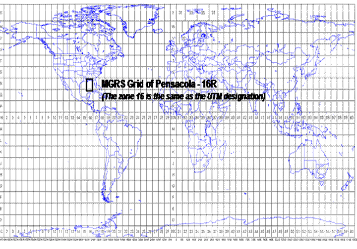
The MGRS system is based on and is an extension of the UTM. It is a reference coordinate system used by the US military and NATO. The grids are divided into 6 degree zones, with subdivisions of 6 degrees wide by 8 degrees high south of the equator (recall that UTM extends to 80 degrees S) and subdivisions of 6 degrees wide by 12 degrees high north of the equator (and recall that UTM extends 84 degrees N). Each of the 6X8 or 6X12 zones is subdivided by letters (in the Pensacola example DU) and finally into numerical coordinates the number of which give the degree of accuracy of the coordinates (FM3-25.36 Chapter 4). Starting from the equator, then, the letters run from A to V for the 100km squares and the letters repeat every 2000km. Since our example is in the northern hemisphere, we'll confine our description to the details specific to the north. The latitude reference starts at 180 degrees the letters A to Z are used in 18 degree increments before they repeat the sequence. In both longitude and latitude the letters I and O are omitted to avoid confusion with the numbers 1 and 0. 16R DU reflects a 100000 meter square within Zone 16. 16R DU 7 6 reflects a 10000 meter square within square 16RDU. 16R DU 78 67 reflects 1000 meter square. 16R DU 780 678 reflects 100 meter square. 16R DU 7806 6781 reflects 10 meter square, and finally, 16R DU 78065 67814 reflects 1 meter square. Image Courtesy of ECP Mountaineering Land Navigation Outline. Edited to show location of Major Grid containing Pensacola.
State Plane Coordinates (SPCs) For Pensacola: The State Plane Coordinates can be calculated online at http://www.ngs.noaa.gov/cgi-bin/spc_getpc.prl and for Pensacola are as follows for NAD83: ======================================================= FL033(ESCAMBIA CO.) NAD83 ZONE = 0903 (LAMBERT|NORTHERN ZONE) The coordinates are further "localized" for accuracy by using the state plane coordinate system. A full set of state by state SPC and UTM data from Comcast Inc., complete with FGDC Metadata can be downloaded in Excel format from http://home.comcast.net/~rickking04/gis/spc.htm. From line 342 for Escambia County, we see that the data for the County are:
| ||||||||||||||||||||||||||||||||||||||||||||||||||||||||||||||||||||||||||||||||||||||||||||||||||||||||||||||||||||||||||||||||||||||||||||||||||||||||||||||||||||||||||||||||||||||||||||||||||||||||||||||||||||||||||||||||||||||||||||||||||||||||||||||||||||||||||||||||||||
|
State Plane Coordinates are not a projection but a separate coordinate system (more on the projection used later). From the table above, it is apparent that there are 2 coordinate systems for this part of Florida, one based on the NAD27 (measured in feet) and another based on the NAD83 (measured in meters). State Plane coordinate systems came into being in the 1930's to provide a common reference to both mappers and surveyors and divides the US into 120 zones - Florida having 3 separate zones. If the state has a large East-West expanse the Lambert conformal projection is used. If the state in question has a large North-South expanse, a transverse Mercator projection will be used. The driver here is of course the shape of the area being mapped with the idea being to provide the most accuracy locally as possible. Florida, because of its size and unique shape is divided into three SPC zones - east, west and north. SPC systems are well suited to the needs of the average surveyor. Some local governments still use the SPC system for local mapping, public works projects and GIS projects. Therefore, Zone 3 of Florida uses a Lambert projection based on its long East -West expanse. When I was working in South Florida for a Civil Engineering firm, the data collected by our survey teams was referenced to an SPC coordinate system used in the zone for South East Florida. The coordinates are all stated in terms of Eastings and Northings, and all angles are based on the 90 degree angles being preserved from the standard parallels. When we look at all the systems we can see the evolution of the art of navigation and surveying before us. The first mariners could navigate by following various landforms (hills, estuaries, etc.) from coastal town to coastal town and the maps and methods they used reflect the level of technology that had available to them. They could determine where they were in terms of latitude, but longitude could not accurately be determined. This in effect limited the degree of commerce and trade options available to early cultures. The maps they made reflected landforms and shapes, but were very inaccurate in terms of preserving things like size and distance. This continued as an issued well into modern times until John Harrison invented a Marine Chronometer in the mid-18th century (Sobel, 1995). In modern times more accurate methods of navigation evolved as technology improved. Better maps and methods made for better (and more diverse) methods of expressing distances on paper maps. What couldn't be completely accounted for were the measurement and modeling errors of trying to account for a non-spherical planet - the oblate spheroid we live on. As weapons technology improved, the uses of the mapping reference systems created new requirements for more local accuracy in targeting for those weapons - particularly in the field of artillery targeting and infantry tactics. Smaller but more accurate maps drove a revision and extension of the UTM system to be more accurate on a more local scale that could be used by the soldier on the battlefield.
| ||||||||||||||||||||||||||||||||||||||||||||||||||||||||||||||||||||||||||||||||||||||||||||||||||||||||||||||||||||||||||||||||||||||||||||||||||||||||||||||||||||||||||||||||||||||||||||||||||||||||||||||||||||||||||||||||||||||||||||||||||||||||||||||||||||||||||||||||||||
|
Other Maps Available Of Pensacola
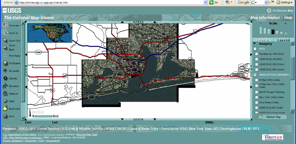
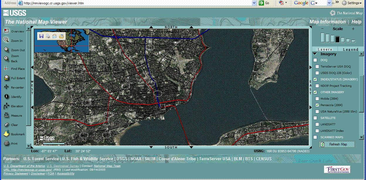
The USGS National Map website at http://nmviewogc.cr.usgs.gov/viewer.htm shows many available datasets available in the viewer at the same time. It also provides multiple coordinate sets depending on where you put the cursor - here the Geographic coordinates as well as coordinates in the National Grid System are displayed. Since metadata available for the imagery specifies it as 0.5m, it's possible to zoom in to a very good level of detail. The imagery is from 2004.
Interactive Google Earth Links to My Hometown, my current offices in Heidelberg and Stuttgart, Germany and Air War College at Maxwell AFB, AL (Click on the "Eyeball" Link to View)
Location at Terraserver ________________________________________________________________________________________________________________ If you're more curious about Pensacola (weather and surf conditions) in "real time" there are a number of locations with webcams that refresh frequently (every 10 seconds or so) located at http://pensacolabeachtoday.com/modules.php?name=Webcams# and http://www.navarrebeachwebcam.com/. For a more historical and tourist overview provided by the Pensacola Chamber of Commerce go to http://video.google.com/videoplay?docid=8694550289581797001&hl=en for a short video. An Escambia County GIS site is located at: http://ims.co.escambia.fl.us/escambiagis/viewer.htm that shows more local details and the local uses of GIS technology in the city and surrounding county. Sources No author, State Plane Coordinate Data, Comcast Inc, Downloaded 9Feb2007 from http://home.comcast.net/~rickking04/gis/spc.htm. DiBiase, D. (1999-2004). The Nature of Geographic Data, Lesson 2, Part IV, Section B. The Pennsylvania State University World Campus Certificate Program in GIS. Retrieved Jan 25, 2007. DiBiase, D. (1999-2004). The Nature of Geographic Data, Lesson 2, Part V, Section A. The Pennsylvania State University World Campus Certificate Program in GIS. Retrieved Jan 25, 2007. ECP Mountaineering Land Navigation Outline; http://www.pittecp.org/schools/mountaineering/site/Classes/Class,%20Land%20Navigation.doc; accessed 28Jan07. FM3-25.36 Chapter 4 Grids; http://www.globalsecurity.org/military/library/policy/army/fm/3-25-26/ch4.htm#fig4-11 accessed on Global Security.org on 28Jan2007. National Geodetic Survey (2007) SPC Utilities. http://www.ngs.noaa.gov/TOOLS/spc.html Accessed 9 February 2007. Penn State Online GIS Education (2005). “Interactive Album of Map Projections”. Retrieved 25Jan2007, from http://projections.mgis.psu.edu/. Sobel, Dava; “Longitude”; (ISBN 0-14-025879-5); Penguin Books, 1995. Troutman, Jeremy; Number Systems; http://www.math.wichita.edu/history/topics/num-sys.html#babylonian accessed January 27, 2007. United States Geological Survey; National Map Viewer; http://nmviewogc.cr.usgs.gov/viewer.htm; accessed 27Jan2007. United States Geological Survey; GNIS Name Server (Query Engine);. http://geonames.usgs.gov/pls/gnispublic/f?p=161:1:15060316272325535722::NO::: ; accessed 9Feb2007. Van Helden, Albert; “Longitude at Sea”; http://cnx.org/content/m11963/latest; accessed 24Jan2007. | ||||||||||||||||||||||||||||||||||||||||||||||||||||||||||||||||||||||||||||||||||||||||||||||||||||||||||||||||||||||||||||||||||||||||||||||||||||||||||||||||||||||||||||||||||||||||||||||||||||||||||||||||||||||||||||||||||||||||||||||||||||||||||||||||||||||||||||||||||||
|
This document is published in fulfillment of an assignment by a student enrolled in an educational offering of The Pennsylvania State University. The student, named above, retains all rights to the document and responsibility for its accuracy and originality.
|