The night is quiet. The family is asleep and all is seemingly peaceful. Unfortunately, evil is almost within reach of them and when it touches this family in Central Africa none of their lives will ever be the same. Before the night is over, they will all be awakened, the children will witness the murder of their parents, the burning of their village and all the children of the village will be marched at gunpoint into the bush perhaps never to be seen again – until they have been brutalized and become puppets of evil performing the same atrocities on the next set of victims.
These are the tactics of the Lord’s Resistance Army – the LRA. The Lord’s Resistance Army is led by Joseph Kony, an ethnic Acholi (Uganda) from northern Uganda. The group’s ideology and objectives are vague – they have pledged to rule Uganda by the Bible’s Ten Commandments. The group uses terror to induce fear and control over civilians and amasses supplies and personnel (child soldiers and sexslaves) by attacking villages. In 2005, military pressure forced the LRA out of Uganda and while now in “exile” they operate primarily in the NE Democratic Republic of the Congo (DRC), south Sudan and the Central African Republic (CAR). These regional governments lack the ability to maintain security in LRA afflicted areas and when combined with the remoteness of the area, allows the LRA to continue to demonstrate the ability to survive in this inaccessible region.
Transient populations are often associated with regional conflicts and are referred to as internally displaced persons (IDPs). Predicting them ahead of time is difficult if not impossible. The populations of remote places in Central Africa are often vulnerable and as a result often victimized. Is it possible to use available data in a manner similar to local law enforcement to predict what may be the next course of action (COA)? The answer is yes. I attempted in September 2011, to document and analyze using spatial statistics, the activities of the Lord’s Resistance Army (LRA) in the period of 2009-2011. This analysis is derived from geospatial, unclassified open source intelligence that include open source press statements, academic journals and articles, and international and NGO databases. A successful prediction was actually made. Many in the world are now aware thanks to the phenomena of the Kony 2012 video that went viral in March of 2012, but there were always a few that always knew and struggled to make the world realize what was happening.
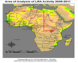
Figure 1. Africa is a huge landmass that could easily contain much of the rest of the world’s land areas with room left over. The large red box above depicts an area that could contain the lower 48 of the US. The smaller red box is the area of our analysis. We will refer to this area as the Tri-Border region. The smaller red box is the Area of Operations (AO) of the LRA. As depicted it is approximately 125,000 square miles but fluctuates as attacks occur. For comparative purposes the total area of California is 158,706 square miles. So the AOI defined by the smaller red box is approximately the size of the state of California. The blue arrows represent traditional trade and smuggling routes. This is important because if it’s hard to get goods thru or to an area, it’s hard to get help, aid and assistance in. This contributes directly to the longevity of the LRA since these routes bypass their AO.
When one considers issues in Africa if you don’t consider the aspects of geography you are doomed to fail with whatever efforts you attempt to make on any issue – humanitarian or otherwise. We first have to begin with a basic understanding of the scope of the problem based on such geographic factors as size and the difficulty of access to areas that lack basic infrastructure such as roads and communications. Africa is over 30.3 million square km. Combined, the lower 48 of the US, India, Argentina, Western Europe, the British Isles and China make up just 29.8 million square km, so, these entire landmasses could be fitted into the boundary of the continent with 500k square km to spare.
The area the LRA operates within comprises one of the poorest and most isolated areas of the world – both factors that contribute to the longevity of the LRA. Roads and communication in the LRA’s area of operation are severely degraded, hindering international and regional trade. While al-Qaida affiliates, such as AQIM, rely on major trade routes and smuggling networks for facilitation, day-to-day sustainment, and operational movement, these major trade routes are not a supporting factor for the LRA. Inaccessibility in this area leaves villages cut off from security and humanitarian services and creates the circumstances that allow the LRA to take advantage of them for recruits and logistical support. In mid-March and early May 2011, elements of the LRA transitioned to CAR, and their attacks have left at least scores dead, 10,000 displaced, and 411 people fleeing to the DRC.
The LRA is a major factor of regional instability in the area between northeastern DRC, northern Uganda, south Sudan and CAR. In December 2008, the Ugandan Army launched “Operation Lightning Thunder” aimed at hunting down Joseph Kony and destroying the LRA military capabilities, but the result was that the LRA became even more regionalized with continuous foraging movements of smaller cells between each of the three countries in the tri-border region. Today, the majority of LRA ground force is comprised of child soldiers, with some estimating the number around 80% of the total strength of the force.
Uganda’s description of the Lightening Thunder operation in 2008, as being a success ignores the secondary effects it has had on destabilizing the entire region. The Ugandan government characterizes the LRA as a “causeless and homeless group” and it’s position it that is has killed or captured more than 350 LRA fighters and states there are only about 200 remaining. By the LRA’s fluid nature, it’s very difficult to determine who is a fighter and who is not (child soldiers or slaves?). The LRA is constantly kidnapping villagers, killing many and training others to become fighters while keeping still others – women and girls in particular – as laborers and sex slaves. One question is hard to answer – with thousands abducted, what have become of the majority if the count is now actually down in the few hundreds as the Ugandan government maintains? Is it possible using GIS methods to detect patterns in the attacks that can provide estimates of the numbers of groups and the high probability areas of where the next attacks might occur?
While it is a remote area, it is not completely unknown. The tri-border region between DRC, Sudan, and CAR share one predominant ethnic identity and language – Azande. A shared culture and frequent intermarriage result in continuous cross-border movement throughout the region and so it is a perfect example of an “ungoverned space.” The religion among the Azande is historically animist blended with modern-day Christianity, but on the whole they are deeply superstitious – and this factor plays into the psyops practiced by the LRA. Subsistence agriculture remains the backbone economic activity of the region.
The word Azande means “the people who possess much land”, and refers to their history as conquering warriors. The Azande land is tropical rain forest that enjoys high annual rainfall. This makes it a an area with a very high agricultural potential. The Azande are subsistence farmers and grow food crops such as maize, cassava, and mangoes etc. http://www.gurtong.net/Peoples/PeoplesProfiles/Azande/tabid/179/Default.aspx. This contributes to making a target of convenience for LRA. Their tribal region extends all through the tri-border area. They speak Zande, which they call Pazande in their own tongue. It is an Adamawa-Ubangi derived language. They have been traditional small-scale farmers and settled land owners, raising only chickens until the 1980s; but now they also include goats and pigs. Their traditional beliefs in magic and witchcraft, known as ‘mangu’, are strong. Several near-daily rituals exist that focus on protection from or canceling out the powers of witchcraft. Although non-government organizations (NGOs) do frequent these areas, the remoteness of the location, lack of security, and LRA attacks make it difficult and dangerous to establish a presence for humanitarian aid or even quick response from military forces.
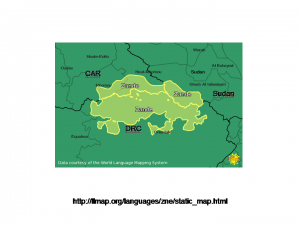
Figure 2. Range of the ethnic language group of the Azande – the primary group in the tri-border region and the main targets of the LRA – currently. From http://llmap.org/languages/zne/static_map.html accessed on 21Aug2011.
An NGO organization in Norway maintains the primary source of attack/event data used in my pattern analysis. The Armed Conflict Location and Event (ACLED) Dataset is maintained by the Center for Conflict Studies in Oslo. The dataset encodes location data of all reported conflicts in 50 countries in the developing world and the LRA is prominent among the perpetrators of violence in attacks spanning over 25 years. The data are derived from a variety of open sources and can be used in any GIS mapping program.
In Figure 3, the results of a Kernel Density Estimate (KDE) are displayed. Two areas and two different contrasting patterns emerge on examination of this map. There seem to be two distinct clusters associated with two separate Conservation areas, one being the Garamba National Park located on the south Sudan-NE DRC border and one located contiguous to a second area that stretches along the northern DRC-southern CAR border. What also might facilitate the movement of the LRA is the presence of a road or a trail, that allows for quick access to and egress from an event area. While the roads are not good enough to allow for quick response by either Sudanese, CAR, DRC or UPDF (Ugandan Peoples Defense Forces) forces and their associated heavy equipment, they are good enough to allow a small mobile tactical force armed only with light weapons like the LRA freedom and ease of movement in and out of their hiding areas inside the protected and heavily forested areas. The populated places expressed in Figure 3, come from the CIESEN database of Columbia University.
So while this analysis is interesting is it of itself useful? Given the sheer size of the area, the lack of infrastructure and the lack of resources to combat the LRA combined with 3 countries whose attitudes towards each other can sometimes be contentious, the answer would seem to be no, but there is a pattern of movement that may be of some use. The analysis should ideally be in support of a group engaged in the hunt for the LRA, or analysis by itself satisfies little. When examining the various incidents over time, activity seemed to be focused in the NE DRC in 2009, and move westward along the CAR DRC border in 2010. The data published by the UN for the first half of 2011, indicated attacks moved back eastward in the NE DRC region. They have since moved into CAR as well.
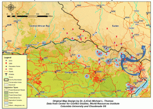
Figure 3. KDE analysis of the tri-border region. The bulk of the attacks seem co-located near what roads there are and protected conservation areas. Combined these two features provide quick access to populated areas from the heavily forested areas, such as Garamba National Park, on the border with south Sudan. It provides ample areas for cover and concealment after an attack against a local population has taken place. This is confirmed by a visual inspection of a similar map produced by the Enough project, an NGO whose homepage is www.enoughproject.org .
Assessments and Recommendations.
The LRA is a unique threat that occupies a large area spanning three borders in Central Africa. The LRA is able to take advantage of political and geographic terrain that hinders both regional and international cooperation. Furthermore, the LRA remains a significant challenge to humanitarian aid due their high mobility and capability to carry out sudden attacks in an unsecure region.
- The dramatic increase in IDPs throughout Orientale Province (DRC) is directly attributed to the persistent state of insecurity caused by LRA presence. Humanitarian access to affected populations remains difficult due to poor security conditions and minimal paved road infrastructure.
- Based on vegetation pattern data from the World Resource Institute, it seems that the most highly correlated factor associated with LRA presence in an area is dense forest. However, the other factors that appear to primarily attract LRA activity are related to population – they need a supply of “labor”. These populated places provide logistical support in the form of food, supplies, and labor from the traditional farmers. Things that are repellant factors are lacking in my assessment, because the LRA is a reactionary group that moves quickly in response to the changing environment, such as transient populations and military operations.
- One recommendation would be for improved intelligence sharing among all regional partners to provide consistent information and to improve cross-border coordination, which would further aid security and humanitarian assistance. The problem with this is the fact that many of the regional partners have issues with each other (i.e. Uganda’s 1990’s invasion of DRC and water disputes between Uganda and Sudan over water rights on the Nile River) and may not be able to cooperate to the degree necessary.
- Another recommendation would be better mapping of IDP camps and the movement of populations within the camps which could result in improved future analysis that supports and better directs future security and humanitarian efforts in the region.
- The construction of a major road in the region would significantly open up remote areas and give easier access to security and humanitarian aid in susceptible areas. What hinders response time by both humanitarian NGOs and security response forces from the 3 nations is also a supporting factor for the LRA.
- Improved telecommunications in the region could shorten security and aid response time. An HF network is being established by Catholic missionaries incrementally in DRC as funding is available (see Figure 4). This was identified as a strategy by Catholic missionaries in their plan Invisible Children Protection Plan. The increased HF radio network would be used an early warning mechanism. Analysis of this type of data would allow for partners to provide equipment to fill in gap areas with no coverage. Security force monitoring would allow for a quick response to get moving if an appeal for help went out. Coordination of efforts using all available resources could drastically diminish the LRA’s ability to function. There is a significant lack of diverse and continuous data available for this AOI. What data is available, especially from NGOs, tends to be fragmented, compartmentalized, difficult to acquire and in multiple formats with varying degrees of accuracy and timeliness.
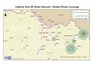
Figure 4. HF radio network being implemented by the Catholic church in NE DRC. From https://salsa.democracyinaction.org/o/2241/images/FINAL_From%20Promise%20to%20Peace_Resolve%20Publication.pdf. Accessed on 26Aug2011. Locations of the stations is not available online – an example of data being held at the local level or by NGOs with no central repository. Availability of data and coordination of efforts would greatly enhance counter LRA efforts.